Unique in Everyway
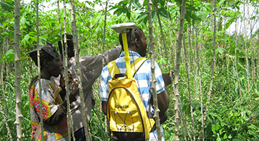
Losamills Consult Ltd is a firm registered in Ghana, in 1996, to undertake surveying and other geo-informatics assignments. The firm has since undertaken several survey and demarcation assignments, involving consultancies on land-use and administration, ground control surveys, cadastral surveys and engineering surveys for government and private organizations as well as private individuals and groups.
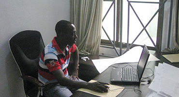
We also have considerable experience in designing, building and managing spatial data using fully-integrated GIS applications to intuitively access, interrogate and analyze all data associated with a development project. We work closely with clients to develop bespoke GIS database and build quality spatial data to suit each project’s needs whilst providing targeted functionality.
The company has qualified Geomatic Engineers, GIS Specialists, Surveyors and Technicians, capable of undertaking any mapping and GIS job. The Founder and Managing Director of the Company is Samuel Larbi Darko, a Geodetic Engineer, a Licensed Surveyor, a member of the International Federation of Surveyors (FIG) and a Fellow of the Ghana Institution of Surveyors (FGhIS) with over thirty-five years of professional experience.
exceptional

What makes us stand out
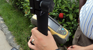
We have a team of qualified, skilled and competent staff made up of geomatic engineers, land surveyors, GIS specialist and technicians who are experienced in modern land surveying technology and project management administration, land valuation, information and data management system.
the search

a brief on our exploitation, and counting...
Our team has worked with the World Bank and other major international and multilateral agencies including International Development Agency (IDA),kwf and other international donor funded institutions, and have a depth of knowledge, expertise and capability to meet the high quality standards required.
motivation

we are fired up to do our best, and give out more...
Surveying has become our lifestyle as a firm. Due to our high and accurate products that we churn out to our clients. We always update and upgrade our equipment and also train our staff to attain the highest skills in our profession, knowing that our best work is always our next work.
the roots of our specialty
The founder and Management team of this great company.
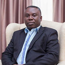
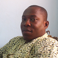
Ing. Surv. Samuel Larbi Darko (Founder & CEO)
Ing. Surv. Samuel Larbi Darko is the CEO of Losamills. He has over 35 years of experience in land survey and digital mapping services, as well as delivering and managing complex projects. Samuel is responsible for charting the strategic direction of the company, in support of our local and international growth plans. Overseeing the commercial and technical roadmaps for Losamills’ ever-expanding suite of high-quality mapping products. Samuel has a passion for technical innovation and is a regular speaker at international conferences and trade shows. He holds degrees in MSc Integrated Map and Geo-information Production (ITC, Netherlands), BSC Geomatic Engineering (Kwame Nkrumah University, Ghana), Graduate Diploma in Law (University of Law, UK),Trainings in GPS Surveying(Trimble Navigation Ltd, UK), ArcGIS I&II(ESRI, USA), and System Development for Project Managers (ISS, Singapore).

Lois Darko (Executive Director)
Lois oversees the evaluation and management of employee performance as well as promotes employee training and development that aligns with Company’s prospects and professional standards. She has passion for devising and executing mission critical strategy and developing new markets for Losamills’ mapping products and services. She works closely with the CEO to create new businesses and manages the relationships with all Losamills’ valued customers and partners. She holds a degree in BSc Geomatic Engineering (Kwame Nkrumah University, Ghana), Postgraduate Diploma in Legal Studies (Ghana School of Law, Ghana) and certificate in Project Management (Marymount California University, USA).
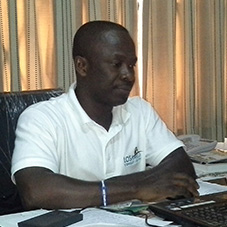
Ing. Surv. Alex Awah-Mensah Jnr. Alex Awuah (Technical Manager)
Alex leads our teams of Geomatic Engineers, Land Surveyors and Geographical Information Systems (GIS) specialists in producing, and maintaining Losamills’ industry-leading geospatial and mapping services. He has over 15 years of experience in land survey and mapping products and is responsible for Losamills’ technical strategy. He holds degrees in MSc. Environmental Science, Policy and Management (Institute of Local Government Studies-Ghana) and BSc Geomatic Engineering (Kwame Nkrumah University, Ghana)
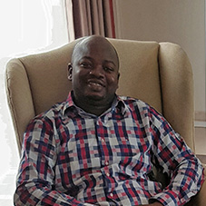
Simon Adams (Projects Coordinator)
Simon a highly dedicated and organized projects coordinator with a diverse work history and more than 10 years of leadership experience. He oversees and manages Losamills projects from conceptual phase through completion. He is passionate about finding the best way to complete project mission, and have demonstrated successful leadership of several large-scale projects. His strong team work management and excellent leadership skills allow him to improve employee cooperation with both internal and external partners. He holds a degree in BSc Geomatic Engineering (Kwame Nkrumah University, Ghana)

Andrews Kwesi Afforo (GIS Business Manager)
Afforo is a highly experienced geospatial professional with a technical, operations and management background who thrives on developing GIS process and products. His skills base spans across geospatial analysis, spatial modelling, database management, data quality control and project management. He loves working closely with our customers, tailoring geospatial solutions to meet their specific requirements whilst delivering valuable business insights. He holds degrees in MSc. Geographical Information Systems (University of Brighton-UK), BSc Geomatic Engineering (Kwame Nkrumah University, Ghana), Executive Mastery in Project & Contract Management (GSGL, Ghana) and Certificate in ArcGIS Pro Training (ESRI, USA)
Offosu Pinton
Pinton is a reliable financial accountant with over 10 years managing financial data and account records in our fast paced accounting department. He belongs to the Association of Charted Certified Accountants with qualification in ACCA Part Two and member of Charted Institute of Taxation (Ghana)